

Chanteloube Viaduct

No reviews yet
Have you flown here? Share your experience with other pilots.
+ Write the first reviewDescription
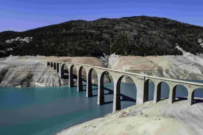
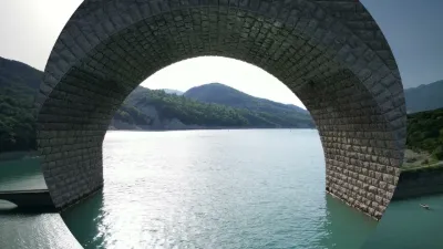
In the majestic setting of Lake Serre-Ponçon, where the mountains of the Hautes-Alpes plunge into captivating blue water, a timeless relic lies dormant: the Chanteloube viaduct, also known as the Moulettes viaduct, located in the bay of the same name, in the municipality of Chorges. Sometimes submerged, sometimes revealed by the whims of the lake, the viaduct intrigues and captivates, offering a fascinating sight to those who venture there. A forgotten railway project, a submerged legend Conceived at the beginning of the 20th century to link Gap to Barcelonnette by rail, the Chanteloube viaduct never saw a single train pass. Begun in 1909, this ambitious project came to an abrupt halt in 1935, leaving behind a ghost structure. It was originally meant to cross the valley of the Moulettes torrent, an essential watercourse in the valley.
When the Serre-Ponçon dam was commissioned in 1961, the viaduct was swallowed up, its fate sealed by the rising waters of the lake. The landscape changed radically, and the valley became the Baie des Moulettes, also called the Baie de Chanteloube.
Map and restricted areas
Open in the main mapNearby aerodromes
Open aerodromes within 25 km of the spot, heliports included, with their distance and direction from the spot. Near an aerodrome, drone flying is prohibited or height-limited: check the UAS zones map.
| Aerodrome | Type | Distance | Elevation | Difference |
|---|---|---|---|---|
| Hôpital Heliport | Heliport | 19 km W | 759 m | spot 61 m higher |
| Seyne les Alpes Glider Field | Aerodrome | 20 km S | 1,200 m | spot 380 m lower |
| Gap - Tallard Airfield | Aerodrome | 22 km W | 605 m | spot 215 m higher |
Aviation weather (METAR and TAF)
No METAR station within 50 km.
Weather and Kp index
| Day | Weather | Temp. min. / max. | Wind | Rain | Max Kp |
|---|---|---|---|---|---|
| Sat 21 Nov | Fair | 5° / 13° | 6 km/h SW | – | 2 |
| Sun 22 Nov | Showers | 4° / 9° | 16 km/h W | 30 mm | 2 |
| Mon 23 Nov | Cloudy | 1° / 7° | 12 km/h SW | – | 4 |
| Tue 24 Nov | Cloudy | 1° / 11° | 8 km/h E | 0.3 mm | 2 |
| Wed 25 Nov | Heavy rain | 3° / 6° | 16 km/h E | 26 mm | – |
| Thu 26 Nov | Clear sky | 1° / 7° | 4 km/h E | 1.0 mm | – |
| Fri 27 Nov | Partly cloudy | -4° / 8° | 7 km/h E | – | – |
Hour by hour: Saturday 21 November
| Time | Weather | Temp. | Wind | Rain | Clouds | Kp |
|---|---|---|---|---|---|---|
| 10:00 | Partly cloudy | 7° | 6 km/h SE | – | 68 % | 2 |
| 11:00 | Partly cloudy | 9° | 6 km/h SE | – | 75 % | 2 |
| 12:00 | Fair | 11° | 5 km/h S | – | 32 % | 2 |
| 13:00 | Fair | 12° | 5 km/h SW | – | 30 % | 1 |
| 14:00 | Clear sky | 13° | 6 km/h SW | – | 11 % | 1 |
| 15:00 | Partly cloudy | 12° | 6 km/h SW | – | 42 % | 1 |
| 16:00 | Partly cloudy | 11° | 5 km/h S | – | 68 % | 2 |
| 17:00 | Partly cloudy | 9° | 2 km/h E | – | 84 % | 2 |
| 18:00 | Cloudy | 8° | 3 km/h E | – | 90 % | 2 |
| 19:00 | Partly cloudy | 7° | 4 km/h E | – | 77 % | 2 |
| 20:00 | Partly cloudy | 6° | 4 km/h E | – | 87 % | 2 |
| 21:00 | Cloudy | 5° | 6 km/h E | – | 94 % | 2 |
| 22:00 | Cloudy | 5° | 6 km/h E | – | 100 % | 2 |
Hour by hour: Sunday 22 November
| Time | Weather | Temp. | Wind | Rain | Clouds | Kp |
|---|---|---|---|---|---|---|
| 06:00 | Heavy rain | 7° | 8 km/h E | 1.5 mm | 100 % | 2 |
| 07:00 | Heavy rain | 7° | 8 km/h NE | 2.7 mm | 100 % | 2 |
| 08:00 | Heavy rain | 8° | 8 km/h NE | 4.0 mm | 100 % | 2 |
| 09:00 | Heavy rain | 8° | 5 km/h NE | 3.3 mm | 100 % | 2 |
| 10:00 | Heavy rain | 8° | 6 km/h NE | 2.1 mm | 100 % | 2 |
| 11:00 | Rain | 8° | 16 km/h W | 0.5 mm | 99 % | 2 |
| 12:00 | Heavy rain | 9° | 16 km/h SW | 1.6 mm | 100 % | 2 |
| 13:00 | Showers | 8° | 15 km/h W | 1.7 mm | 74 % | 2 |
| 14:00 | Showers | 8° | 12 km/h W | 0.7 mm | 73 % | 2 |
| 15:00 | Showers | 8° | 13 km/h W | 0.9 mm | 57 % | 2 |
| 16:00 | Showers | 7° | 12 km/h W | 0.6 mm | 68 % | 2 |
| 17:00 | Showers | 7° | 13 km/h W | 0.4 mm | 58 % | 2 |
| 18:00 | Showers | 6° | 11 km/h W | 0.1 mm | 64 % | 2 |
| 19:00 | Showers | 6° | 10 km/h SW | 0.4 mm | 71 % | 2 |
| 20:00 | Showers | 5° | 8 km/h SW | 0.3 mm | 77 % | 2 |
| 21:00 | Showers | 5° | 8 km/h SW | 0.3 mm | 73 % | 2 |
| 22:00 | Heavy rain | 4° | 7 km/h S | 1.2 mm | 98 % | 2 |
Sunrise and sunset
| Day | Dawn | Sunrise | Golden hour | Sunset | Dusk | Day length |
|---|---|---|---|---|---|---|
| Sat 21 Nov | 07:07 | 07:39 | 07:39–08:24 · 16:17–17:02 | 17:02 | 17:34 | 9 h 23 |
| Sun 22 Nov | 07:08 | 07:40 | 07:40–08:26 · 16:16–17:02 | 17:02 | 17:34 | 9 h 21 |
| Mon 23 Nov | 07:09 | 07:41 | 07:41–08:27 · 16:15–17:01 | 17:01 | 17:33 | 9 h 19 |
| Tue 24 Nov | 07:11 | 07:43 | 07:43–08:28 · 16:14–17:00 | 17:00 | 17:32 | 9 h 17 |
| Wed 25 Nov | 07:12 | 07:44 | 07:44–08:30 · 16:14–17:00 | 17:00 | 17:32 | 9 h 15 |
| Thu 26 Nov | 07:13 | 07:45 | 07:45–08:31 · 16:13–16:59 | 16:59 | 17:31 | 9 h 13 |
| Fri 27 Nov | 07:14 | 07:46 | 07:46–08:33 · 16:12–16:58 | 16:58 | 17:31 | 9 h 12 |


Reviews
Log in to review this spot. Log in · Create a free account
No reviews yet. Share yours!