

Getaria, San Anton

No reviews yet
Have you flown here? Share your experience with other pilots.
+ Write the first reviewDescription
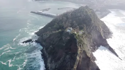
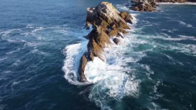
San Anton is the mountain and half-island located off the coast of Getaria, Gipuzkoa, Spain. San Anton is attached to the mainland by a breakwater. It has a steep slope and is one of the most popular places in the Basque Country. It is used mainly for leisure by the local population. The mountain has a nature park. The top of the mountain is flatter and is decorated with trees. Its cliff is formed of rocks, especially the one called Armeria euskadiensis.
San Anton Mountain takes its name from an old hermitage, which was located near the current lighthouse before being destroyed by the French in the first half of the 19th century. It was a prime vantage point for watching whales, whose capture was one of the jobs of people in this town.
This island was intentionally attached to the port in the 15th century. The breakwater was given the name "The Passage" in order to complete the construction of a small harbour for the mountainous island, replacing the old rocky ridge that had been destroyed by a storm. Fortifications, a lighthouse from 1863 and farms such as Abeta, Agoteaundi and Gure Ametsa decorate San Anton.
Map and restricted areas
Open in the main mapAviation weather (METAR and TAF)
LESO – San Sebastián Airport VFR
METAR
METAR LESO 171200Z 00000KT 9999 BKN046 18/16 Q1004
- Wind
- Calm
- Visibility
- 10 km or more
- Clouds
- Broken (5-7/8) at 4,600 ft (1400 m)
- Temperature
- 18 °C, dew point 16 °C
- QNH
- 1004 hPa
- Flight category
- VFR: ceiling > 3,000 ft and visibility > 5 mi
TAF
TAF LESO 171100Z 1712/1812 24009KT 9999 FEW020 SCT060 TX22/1715Z TN15/1806Z TEMPO 1714/1803 23019G29KT PROB30 TEMPO 1803/1807 30010KT 3000 RA BKN010
| Period (local time) | Change | Wind | Visibility | Weather | Clouds |
|---|---|---|---|---|---|
| 17/11 13:00 → 18/11 13:00 | Initial conditions | 240°, 17 km/h | 10 km or more | Few (1-2/8) at 2,000 ft (610 m) ; Scattered (3-4/8) at 6,000 ft (1830 m) | |
| 17/11 15:00 → 18/11 04:00 | Temporarily | 230°, 35 km/h, gusts 54 km/h | |||
| 18/11 04:00 → 18/11 08:00 | Temporarily, probability 30% | 300°, 19 km/h | 3.0 km | Rain | Broken (5-7/8) at 1,000 ft (300 m) |
Weather and Kp index
Sunrise and sunset
| Day | Dawn | Sunrise | Golden hour | Sunset | Dusk | Day length |
|---|---|---|---|---|---|---|
| Tue 17 Nov | 07:34 | 08:05 | 08:05–08:48 · 17:00–17:43 | 17:43 | 18:14 | 9 h 38 |
| Wed 18 Nov | 07:35 | 08:06 | 08:06–08:49 · 16:59–17:42 | 17:42 | 18:13 | 9 h 36 |
| Thu 19 Nov | 07:36 | 08:07 | 08:07–08:51 · 16:58–17:41 | 17:41 | 18:12 | 9 h 34 |
| Fri 20 Nov | 07:37 | 08:08 | 08:08–08:52 · 16:57–17:41 | 17:41 | 18:12 | 9 h 32 |
| Sat 21 Nov | 07:38 | 08:10 | 08:10–08:53 · 16:56–17:40 | 17:40 | 18:11 | 9 h 30 |
| Sun 22 Nov | 07:40 | 08:11 | 08:11–08:55 · 16:55–17:39 | 17:39 | 18:10 | 9 h 28 |
| Mon 23 Nov | 07:41 | 08:12 | 08:12–08:56 · 16:54–17:38 | 17:38 | 18:10 | 9 h 26 |




Reviews
Log in to review this spot. Log in · Create a free account
No reviews yet. Share yours!