

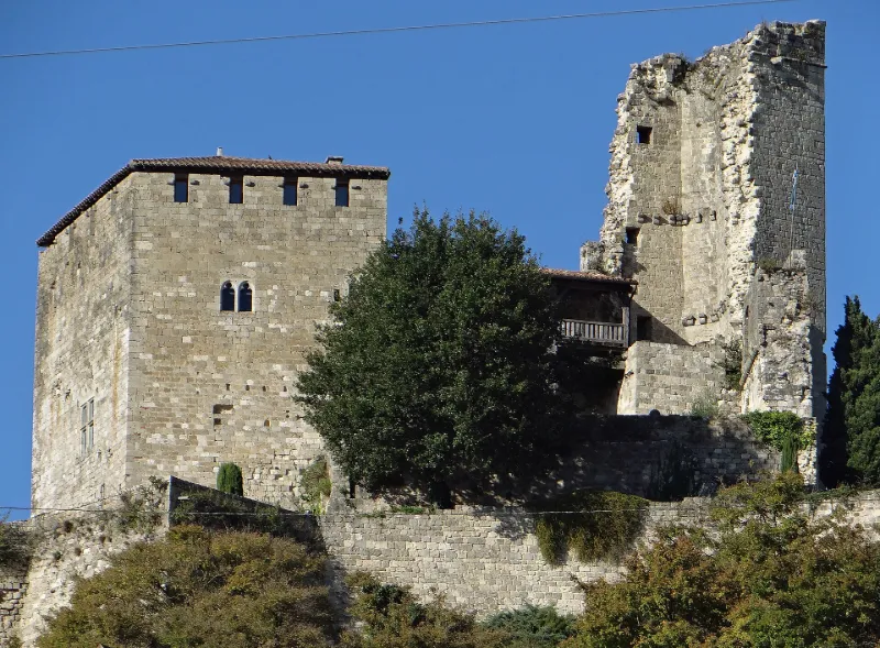
Ruins of the Feudal Castle
No reviews yet
Have you flown here? Share your experience with other pilots.
+ Write the first reviewHistory
Château construit au 13e siècle et légèrement agrandi au cours du 14e siècle. Il a subi plusieurs sièges, dont le plus important et dernier, remonte à 1575 et a été mené par le maréchal de Montluc et les milices d'Agen. Une partie a été démolie à une époque indéterminée. L'enceinte générale est assez irrégulière et formait un enclos qui suivait les irrégularités du promontoire. Du côté est, la défense était assurée par un fossé. Au centre, un massif de constructions rectangulaires forme front vers l'est, et comportait, au centre, une tour constituant une habitation à plusieurs étages. Une sorte de donjon à peu près carré a été ajouté aux constructions précédentes. Il comporte trois étages supportés au centre par une colonne de pierre. A l'ouest, l'enceinte présentait une terrasse où se trouvait une batterie qui répondait aux canons de Montluc.
Map and restricted areas
Open in the main mapRestricted zones
| Zone | Category | Limits | Conditions |
|---|---|---|---|
| Ctr Agen la Garenne |
Zone de contrôle civile | 50 m above ground level → 610 m above sea level | Flights above 50 metres are forbidden without the prior agreement of air traffic control |
| Zena Perigord Low | ZRT | FL 165 / FL 195 | SUP AIP 062/26 · Du jeudi 23 avril 2026 au jeudi 25 mars 2027 |
| Zena Perigord Medium | ZRT | FL 195 / FL 245 | SUP AIP 062/26 · Du jeudi 23 avril 2026 au jeudi 25 mars 2027 |
| Zena Perigord High | ZRT | FL 395 / UNL | SUP AIP 062/26 · Du jeudi 23 avril 2026 au jeudi 25 mars 2027 |
Nearby aerodromes
Open aerodromes within 25 km of the spot, heliports included, with their distance and direction from the spot. Near an aerodrome, drone flying is prohibited or height-limited: check the UAS zones map.
| Aerodrome | Type | Distance | Elevation |
|---|---|---|---|
| Agen-La Garenne Airport | Airport | 9.2 km S | 62 m |
| Montpezat d'Agenais | Aerodrome | 14 km NW | 37 m |
| Villeneuve-sur-Lot Airport | Aerodrome | 21 km NE | 58 m |
Aviation weather (METAR and TAF)
LFBA – Agen-La Garenne Airport IFR
METAR
METAR LFBA 171400Z AUTO 26004KT 230V290 2900 +RA BR SCT006/// BKN012/// OVC019/// ///TCU 14/14 Q1003 TEMPO 3000 RA BKN014 BKN035 FEW060CB
- Wind
- 260°, 7 km/h
- Visibility
- 2.9 km
- Weather
- Rain heavy ; mist
- Clouds
- Scattered (3-4/8) at 600 ft (180 m) ; Broken (5-7/8) at 1,200 ft (370 m) ; Overcast (8/8) at 1,900 ft (580 m)
- Temperature
- 14 °C, dew point 14 °C
- QNH
- 1003 hPa
- Flight category
- IFR: ceiling 500–1,000 ft or visibility 1–3 mi
TAF
TAF AMD LFBA 171415Z 1714/1721 25010KT CAVOK TEMPO 1714/1717 2000 RA SCT005 BKN014 BKN035 FEW060CB TEMPO 1719/1721 3000 RA BKN040TCU
| Period (local time) | Change | Wind | Visibility | Weather | Clouds |
|---|---|---|---|---|---|
| 17/11 15:00 → 17/11 22:00 | Initial conditions | 250°, 19 km/h | 10 km or more | No significant weather | No significant cloud |
| 17/11 15:00 → 17/11 18:00 | Temporarily | 2.0 km | Rain | Scattered (3-4/8) at 500 ft (150 m) ; Broken (5-7/8) at 1,400 ft (430 m) ; Broken (5-7/8) at 3,500 ft (1070 m) | |
| 17/11 20:00 → 17/11 22:00 | Temporarily | 3.0 km | Rain | Broken (5-7/8) at 4,000 ft (1220 m) (towering cumulus) |
Weather and Kp index
Sunrise and sunset
| Day | Dawn | Sunrise | Golden hour | Sunset | Dusk | Day length |
|---|---|---|---|---|---|---|
| Tue 17 Nov | 07:25 | 07:56 | 07:56–08:40 · 16:45–17:29 | 17:29 | 18:01 | 9 h 33 |
| Wed 18 Nov | 07:26 | 07:57 | 07:57–08:42 · 16:44–17:28 | 17:28 | 18:00 | 9 h 31 |
| Thu 19 Nov | 07:27 | 07:59 | 07:59–08:43 · 16:43–17:28 | 17:28 | 17:59 | 9 h 29 |
| Fri 20 Nov | 07:28 | 08:00 | 08:00–08:45 · 16:42–17:27 | 17:27 | 17:58 | 9 h 26 |
| Sat 21 Nov | 07:29 | 08:01 | 08:01–08:46 · 16:41–17:26 | 17:26 | 17:58 | 9 h 24 |
| Sun 22 Nov | 07:31 | 08:02 | 08:02–08:47 · 16:40–17:25 | 17:25 | 17:57 | 9 h 22 |
| Mon 23 Nov | 07:32 | 08:04 | 08:04–08:49 · 16:39–17:25 | 17:25 | 17:56 | 9 h 20 |

Reviews (0)
Log in to review this spot. Log in · Create a free account
No reviews yet. Share yours!