

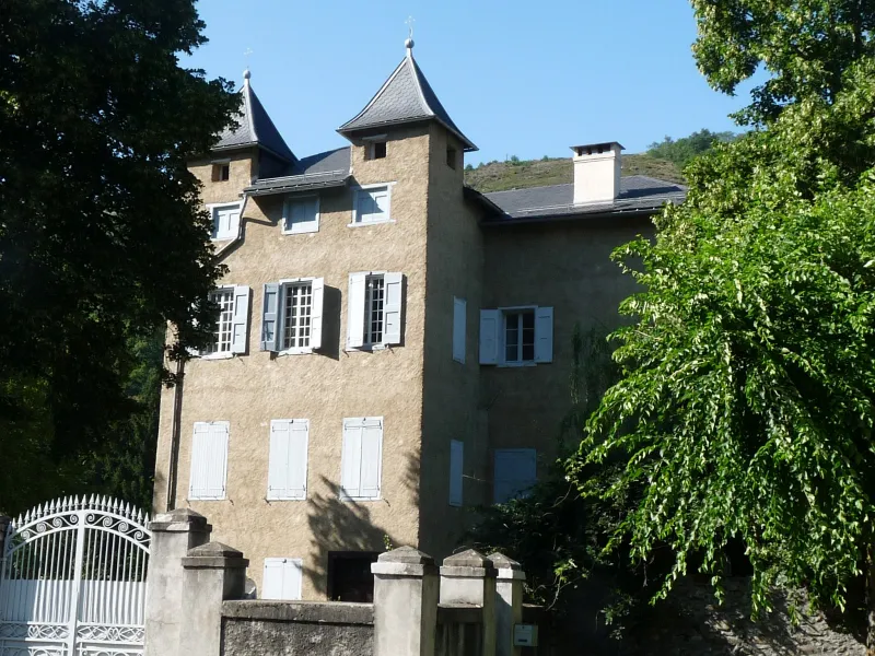
Savignac Castle
No reviews yet
Have you flown here? Share your experience with other pilots.
+ Write the first reviewHistory
16e siècle ; 19e siècle Le château actuel, remanié sous la Restauration, conserve intactes les deux façades nord et ouest datables du 15e siècle. La façade sud, remaniée sous la Restauration, présente un avant-corps plaqué sur le bâtiment du 15e siècle, exemple curieux d'une architecture rustique locale. Il s'agit d'une façade à trois étages flanquée de deux tourelles-pigeonniers avec toiture à quatre pans recouverte d'ardoises taillées en écaille. Le bâtiment du 15e siècle est constitué par le quadrilatère visible depuis l'angle nord-ouest du château. Il est souligné par un rang de corbeaux qui soutiennent la toiture, et par deux échauguettes, l'une carrée sur corbeaux, l'autre circulaire en cul de lampe. A l'intérieur, l'escalier se développe sur trois étages, avec un plafond à la française à la peinture gris clair à liseret rouge.
Map and restricted areas
Open in the main mapRestricted zones
Nearby aerodromes
Open aerodromes within 25 km of the spot, heliports included, with their distance and direction from the spot. Near an aerodrome, drone flying is prohibited or height-limited: check the UAS zones map.
| Aerodrome | Type | Distance | Elevation |
|---|---|---|---|
| Altisurface de Coste Del Palm | Aerodrome | 15 km SE | 2,350 m |
| Altisurface du Clos de Legua | Aerodrome | 15 km E | 2,400 m |
| Mont Llaret Roc d'Aude Airfield | Aerodrome | 18 km SE | 2,350 m |
| Mont Llaret Pic d'Aude Airfield | Aerodrome | 19 km SE | 2,325 m |
Aviation weather (METAR and TAF)
No METAR station within 50 km.
Weather and Kp index
| Day | Weather | Temp. min. / max. | Wind | Rain | Max Kp |
|---|---|---|---|---|---|
| Tue 17 Nov | Light rain | 8° / 13° | 16 km/h SW | 0.4 mm | 5 |
| Wed 18 Nov | Fog | 5° / 9° | 20 km/h S | 2.6 mm | 5 |
| Thu 19 Nov | Clear sky | 0° / 10° | 35 km/h SW | 10 mm | 3 |
| Fri 20 Nov | Partly cloudy | -2° / 7° | 8 km/h NW | – | 3 |
| Sat 21 Nov | Cloudy | 1° / 9° | 9 km/h S | – | – |
| Sun 22 Nov | Partly cloudy | 1° / 6° | 11 km/h W | 3.3 mm | – |
| Mon 23 Nov | Partly cloudy | -0° / 8° | 8 km/h S | – | – |
Hour by hour: Tuesday 17 November
| Time | Weather | Temp. | Wind | Rain | Clouds | Kp |
|---|---|---|---|---|---|---|
| 15:00 | Light rain | 13° | 12 km/h W | 0.2 mm | 100 % | 4 |
| 16:00 | Light rain | 13° | 15 km/h W | 0.2 mm | 100 % | 4 |
| 17:00 | Cloudy | 12° | 16 km/h SW | – | 99 % | 4 |
| 18:00 | Cloudy | 11° | 14 km/h W | – | 98 % | 4 |
| 19:00 | Cloudy | 11° | 10 km/h W | – | 93 % | 5 |
| 20:00 | Partly cloudy | 10° | 9 km/h W | – | 85 % | 5 |
| 21:00 | Partly cloudy | 10° | 6 km/h W | – | 80 % | 5 |
| 22:00 | Partly cloudy | 9° | 6 km/h NW | – | 85 % | 5 |
Hour by hour: Wednesday 18 November
| Time | Weather | Temp. | Wind | Rain | Clouds | Kp |
|---|---|---|---|---|---|---|
| 06:00 | Cloudy | 8° | 6 km/h N | – | 93 % | 4 |
| 07:00 | Cloudy | 7° | 5 km/h SE | – | 100 % | 4 |
| 08:00 | Light rain | 7° | 7 km/h NE | 0.1 mm | 98 % | 4 |
| 09:00 | Light rain | 6° | 6 km/h N | 0.2 mm | 100 % | 4 |
| 10:00 | Fog | 6° | 9 km/h N | – | 100 % | 4 |
| 11:00 | Light rain | 6° | 9 km/h N | 0.3 mm | 100 % | 4 |
| 12:00 | Fog | 6° | 5 km/h N | – | 100 % | 4 |
| 13:00 | Fog | 8° | 7 km/h NW | – | 100 % | 3 |
| 14:00 | Cloudy | 9° | 6 km/h N | – | 96 % | 3 |
| 15:00 | Partly cloudy | 9° | 6 km/h N | – | 85 % | 3 |
| 16:00 | Cloudy | 9° | 6 km/h N | – | 88 % | 3 |
| 17:00 | Partly cloudy | 8° | 5 km/h NE | – | 70 % | 3 |
| 18:00 | Partly cloudy | 6° | 7 km/h SE | – | 68 % | 3 |
| 19:00 | Partly cloudy | 6° | 11 km/h S | – | 66 % | 2 |
| 20:00 | Partly cloudy | 5° | 13 km/h S | – | 77 % | 2 |
| 21:00 | Cloudy | 6° | 15 km/h S | – | 91 % | 2 |
| 22:00 | Light rain | 8° | 20 km/h S | 0.3 mm | 98 % | 2 |
Sunrise and sunset
| Day | Dawn | Sunrise | Golden hour | Sunset | Dusk | Day length |
|---|---|---|---|---|---|---|
| Tue 17 Nov | 07:16 | 07:47 | 07:47–08:29 · 16:46–17:28 | 17:28 | 17:59 | 9 h 41 |
| Wed 18 Nov | 07:17 | 07:48 | 07:48–08:31 · 16:45–17:28 | 17:28 | 17:58 | 9 h 39 |
| Thu 19 Nov | 07:19 | 07:49 | 07:49–08:32 · 16:44–17:27 | 17:27 | 17:57 | 9 h 37 |
| Fri 20 Nov | 07:20 | 07:50 | 07:50–08:33 · 16:43–17:26 | 17:26 | 17:57 | 9 h 35 |
| Sat 21 Nov | 07:21 | 07:52 | 07:52–08:35 · 16:42–17:25 | 17:25 | 17:56 | 9 h 33 |
| Sun 22 Nov | 07:22 | 07:53 | 07:53–08:36 · 16:41–17:25 | 17:25 | 17:55 | 9 h 31 |
| Mon 23 Nov | 07:23 | 07:54 | 07:54–08:38 · 16:40–17:24 | 17:24 | 17:55 | 9 h 30 |
Reviews (0)
Log in to review this spot. Log in · Create a free account
No reviews yet. Share yours!