

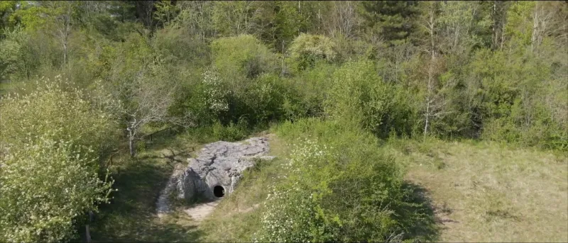
Covered walkway of Guiry-en-Vexin
1 pilot review
“Bonjour , Superbe vidéo … elle donne envie d’aller y faire un tour .” — Breizh666, 4 years ago
Read the reviews + Write my reviewDescription
The building was discovered in October 1915 by a farm worker who stumbled against the stones while ploughing the plot. An initial survey was interrupted when bones were discovered. Due to bad weather, the first excavations carried out by Romain Branchu, a school teacher, and Léon Plancouard, an archaeologist, were interrupted and postponed until early March 1916 and stopped in October 1916. Adrien de Mortillet resumed excavations in September 1919. The building was classified as a historical monument on May 24, 1958, which did not spare it some clandestine excavations and degradation. In July 1960 it was found that the monument still contained some bones and that the archaeological layer had not been completely excavated. The excavations were completed in 1973 and the monument was restored.
Map and restricted areas
Open in the main mapNearby aerodromes
Open aerodromes within 25 km of the spot, heliports included, with their distance and direction from the spot. Near an aerodrome, drone flying is prohibited or height-limited: check the UAS zones map.
| Aerodrome | Type | Distance | Elevation | Difference |
|---|---|---|---|---|
| Base Paramoteurs d' Avernes | Aerodrome | 2.9 km SE | 139 m | same altitude as the spot |
| Mantes Chérence Airfield | Aerodrome | 12 km W | 156 m | spot 19 m lower |
| Aérodrome de Pontoise - Cormeilles en Vexin | Airport | 15 km E | 99 m | spot 38 m higher |
| Les Mureaux Airfield | Aerodrome | 15 km SE | 27 m | spot 110 m higher |
| Flins Heliport | Heliport | 15 km S | 25 m | spot 112 m higher |
Aviation weather (METAR and TAF)
LFPT – Aérodrome de Pontoise - Cormeilles en Vexin VFR
METAR
METAR LFPT 211130Z AUTO 14006KT 9999 FEW010 SCT016 BKN054 11/09 Q1018
- Wind
- 140°, 11 km/h
- Visibility
- 10 km or more
- Clouds
- Few (1-2/8) at 1,000 ft (300 m) ; Scattered (3-4/8) at 1,600 ft (490 m) ; Broken (5-7/8) at 5,400 ft (1650 m)
- Temperature
- 11 °C, dew point 9 °C
- QNH
- 1018 hPa
- Flight category
- VFR: ceiling > 3,000 ft and visibility > 5 mi
TAF
Weather and Kp index
Sunrise and sunset
| Day | Dawn | Sunrise | Golden hour | Sunset | Dusk | Day length |
|---|---|---|---|---|---|---|
| Sat 21 Nov | 07:36 | 08:12 | 08:12–09:03 · 16:14–17:05 | 17:05 | 17:41 | 8 h 53 |
| Sun 22 Nov | 07:38 | 08:13 | 08:13–09:05 · 16:13–17:04 | 17:04 | 17:40 | 8 h 51 |
| Mon 23 Nov | 07:39 | 08:15 | 08:15–09:06 · 16:12–17:03 | 17:03 | 17:39 | 8 h 48 |
| Tue 24 Nov | 07:40 | 08:16 | 08:16–09:08 · 16:10–17:03 | 17:03 | 17:38 | 8 h 46 |
| Wed 25 Nov | 07:42 | 08:18 | 08:18–09:10 · 16:09–17:02 | 17:02 | 17:37 | 8 h 44 |
| Thu 26 Nov | 07:43 | 08:19 | 08:19–09:11 · 16:08–17:01 | 17:01 | 17:37 | 8 h 41 |
| Fri 27 Nov | 07:44 | 08:20 | 08:20–09:13 · 16:07–17:00 | 17:00 | 17:36 | 8 h 39 |

Reviews
Log in to review this spot. Log in · Create a free account
Breizh666
Bonjour , Superbe vidéo … elle donne envie d’aller y faire un tour .