

Panorama of Urville Nacqueville
No reviews yet
Have you flown here? Share your experience with other pilots.
+ Write the first reviewDescription
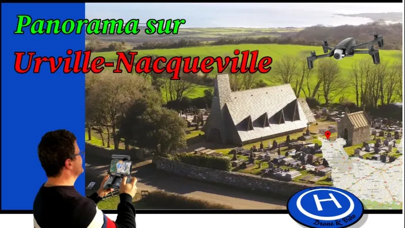
The chapelle Saint-Laurent de Nacqueville is a Catholic building in the Manche department, located in Urville-Nacqueville. It is the third church built in Nacqueville. The old church of Nacqueville, with its gabled bell tower, was demolished in 1902 by Hildevert Hersent, lord of the château de Nacqueville and a civil engineering contractor, who took on the cost of building the new church. The Cherbourg architect René Lévesque designed a 13th-century Gothic-style church, in granite from Flamanville, Gréville and Omonville, and Caen stone. The first stone was laid on 10 August 1902, on the feast of Saint Laurent. The new church was inaugurated on 11 October of the same year. It suffered some damage from lightning on 20 May 1904 and the inventory of 23 March 1906 required by the law on the separation of Church and State[1]. Finally, it was destroyed by the Germans on 4 June 1944. As the bishopric and the prefecture had decided to rebuild only one church for the two communes of Urville and Nacqueville, the latter demanded the construction of a memorial chapel. The chapelle Saint-Laurent was therefore built on the hill, inside the cemetery, on the site of the old church, of which it is the memorial. It is the work of local architects René Levavasseur and M. Lebreton. Inaugurated in 1965, it remained closed for several years and has been used once a year since its restoration in 2012.
- The château de Nacqueville, or château de Fourneville, is a 16th-century residence standing in the Nord-Cotentin, in the French commune of Urville-Nacqueville in the Manche department, in the Normandy region. The Nacqueville estate is partially listed as a historic monument. The gate and its drawbridge were listed by order of 16 May 1944. The façades and roofs of the château and the park with all its water features were listed by order of 20 November 1992.
- The batterie haute de Nacqueville, built between 1878 and 1881, is located on the plateau, near the municipal cemetery. Its armament consisted of three cannons and six howitzers. It suffered a lot of damage during the last world war. Annexed to this battery is a powder magazine located below the plateau. It consists of an entrance gallery that splits into two branches, one of which leads to a storage room. In these galleries you can see two abandoned mine carts on the tracks. Owned by the French Navy, the whole site was acquired by the town hall in 2010.
Map and restricted areas
Open in the main mapNearby aerodromes
Open aerodromes within 25 km of the spot, heliports included, with their distance and direction from the spot. Near an aerodrome, drone flying is prohibited or height-limited: check the UAS zones map.
| Aerodrome | Type | Distance | Elevation | Difference |
|---|---|---|---|---|
| Arsenal-Premar Heliport | Heliport | 7.0 km E | 8 m | spot 92 m higher |
| Aérodrome de Vauville | Aerodrome | 8.4 km SW | 139 m | spot 39 m lower |
| Centre Hospitalier Heliport | Heliport | 9.4 km E | 19 m | spot 81 m higher |
| Crossma Heliport | Heliport | 13 km W | 147 m | spot 47 m lower |
| Flamanville Heliport | Heliport | 18 km SW | 82 m | spot 18 m higher |
Aviation weather (METAR and TAF)
LFRC – Cherbourg-Maupertus Airport LIFR
METAR
METAR LFRC 211130Z AUTO 15009KT 0350 0300 R28/0400N FG VV/// 09/09 Q1016 BECMG 6000 NSW BKN003
- Wind
- 150°, 17 km/h
- Visibility
- 350 m
- Weather
- Fog
- Clouds
- –
- Temperature
- 9 °C, dew point 9 °C
- QNH
- 1016 hPa
- Flight category
- LIFR: ceiling < 500 ft or visibility < 1 mi
TAF
TAF LFRC 211100Z 2112/2121 17010KT 0300 FG VV/// BECMG 2112/2114 6000 NSW BKN003 BECMG 2114/2116 BKN008 TEMPO 2116/2120 BKN011 BECMG 2119/2121 13015G25KT
| Period (local time) | Change | Wind | Visibility | Weather | Clouds |
|---|---|---|---|---|---|
| 21/11 13:00 → 21/11 22:00 | Initial conditions | 170°, 19 km/h | 300 m | Fog | |
| 21/11 13:00 → 21/11 15:00 | Becoming | 170°, 19 km/h | 6 km | No significant weather | Broken (5-7/8) at 300 ft (90 m) |
| 21/11 15:00 → 21/11 20:00 | Becoming | 170°, 19 km/h | 6 km | No significant weather | Broken (5-7/8) at 800 ft (240 m) |
| 21/11 17:00 → 21/11 21:00 | Temporarily | Broken (5-7/8) at 1,100 ft (340 m) | |||
| 21/11 20:00 → 21/11 22:00 | Becoming | 130°, 28 km/h, gusts 46 km/h | 6 km | No significant weather | Broken (5-7/8) at 800 ft (240 m) |
Weather and Kp index
Sunrise and sunset
| Day | Dawn | Sunrise | Golden hour | Sunset | Dusk | Day length |
|---|---|---|---|---|---|---|
| Sat 21 Nov | 07:52 | 08:28 | 08:28–09:20 · 16:25–17:18 | 17:18 | 17:53 | 8 h 49 |
| Sun 22 Nov | 07:54 | 08:30 | 08:30–09:22 · 16:24–17:17 | 17:17 | 17:53 | 8 h 47 |
| Mon 23 Nov | 07:55 | 08:31 | 08:31–09:24 · 16:23–17:16 | 17:16 | 17:52 | 8 h 44 |
| Tue 24 Nov | 07:56 | 08:32 | 08:32–09:26 · 16:22–17:15 | 17:15 | 17:51 | 8 h 42 |
| Wed 25 Nov | 07:58 | 08:34 | 08:34–09:27 · 16:21–17:14 | 17:14 | 17:50 | 8 h 39 |
| Thu 26 Nov | 07:59 | 08:35 | 08:35–09:29 · 16:20–17:13 | 17:13 | 17:49 | 8 h 37 |
| Fri 27 Nov | 08:00 | 08:37 | 08:37–09:31 · 16:19–17:12 | 17:12 | 17:49 | 8 h 35 |



Reviews
Log in to review this spot. Log in · Create a free account
No reviews yet. Share yours!