

Le Bec d'Amont
No reviews yet
Have you flown here? Share your experience with other pilots.
+ Write the first reviewDescription
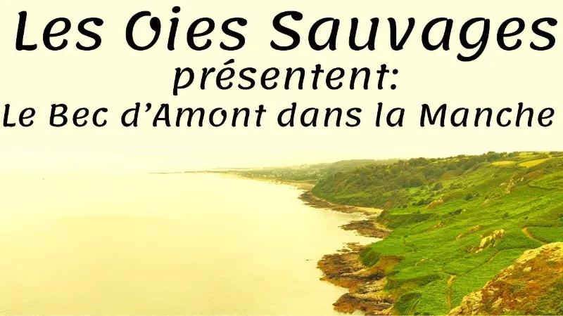
In the Cotentin, you absolutely have to make the most of it as soon as the weather is nice. There's no question of doing anything other than walking the coastal path; you spend a lot of time admiring the scenery...
Loop starting from the village of Gruchy, where Jean-François Millet, the painter of peasant life, was born in 1814. Leaving the hamlet of Gruchy, we gently descend to the seaside at the Bec d'Amont and climb back up the coast along the GR 223, known as the customs officers' path. From the start, it descends very steeply to the Castel Vendon, a rock used for climbing.
A Roman fortress is said to have been built there. In 1792, an earthenware vase containing sixty bronzes and coins from the early Roman Empire was discovered there. Every time we get a view through the bushes, we admire this landscape we dream of all year long.
Map and restricted areas
Open in the main mapNearby aerodromes
Open aerodromes within 25 km of the spot, heliports included, with their distance and direction from the spot. Near an aerodrome, drone flying is prohibited or height-limited: check the UAS zones map.
| Aerodrome | Type | Distance | Elevation | Difference |
|---|---|---|---|---|
| Aérodrome de Vauville | Aerodrome | 8.0 km SW | 139 m | spot 139 m lower |
| Crossma Heliport | Heliport | 9.3 km W | 147 m | spot 147 m lower |
| Arsenal-Premar Heliport | Heliport | 11 km E | 8 m | spot 8 m lower |
| Centre Hospitalier Heliport | Heliport | 13 km SE | 19 m | spot 19 m lower |
| Flamanville Heliport | Heliport | 19 km SW | 82 m | spot 82 m lower |
Aviation weather (METAR and TAF)
LFRC – Cherbourg-Maupertus Airport MVFR
METAR
METAR LFRC 210630Z AUTO 18006KT 7000 NSC 05/05 Q1016 TEMPO 0300 FG VV///
- Wind
- 180°, 11 km/h
- Visibility
- 7 km
- Clouds
- –
- Temperature
- 5 °C, dew point 5 °C
- QNH
- 1016 hPa
- Flight category
- MVFR: ceiling 1,000–3,000 ft or visibility 3–5 mi
TAF
TAF LFRC 210500Z 2106/2115 VRB05KT 9999 SCT020 BECMG 2106/2108 15010KT 3000 BR BKN003 PROB40 TEMPO 2106/2110 0300 FG VV/// BECMG 2110/2112 9999 NSW BECMG 2113/2115 BKN006
| Period (local time) | Change | Wind | Visibility | Weather | Clouds |
|---|---|---|---|---|---|
| 21/11 07:00 → 21/11 16:00 | Initial conditions | Variable, 9 km/h | 10 km or more | Scattered (3-4/8) at 2,000 ft (610 m) | |
| 21/11 07:00 → 21/11 11:00 | Becoming | 150°, 19 km/h | 3.0 km | Mist | Broken (5-7/8) at 300 ft (90 m) |
| 21/11 07:00 → 21/11 11:00 | Temporarily, probability 40% | 300 m | Fog | ||
| 21/11 11:00 → 21/11 14:00 | Becoming | 150°, 19 km/h | 10 km or more | No significant weather | Broken (5-7/8) at 300 ft (90 m) |
| 21/11 14:00 → 21/11 16:00 | Becoming | 150°, 19 km/h | 10 km or more | No significant weather | Broken (5-7/8) at 600 ft (180 m) |
Weather and Kp index
Sunrise and sunset
| Day | Dawn | Sunrise | Golden hour | Sunset | Dusk | Day length |
|---|---|---|---|---|---|---|
| Sat 21 Nov | 07:52 | 08:28 | 08:28–09:21 · 16:25–17:18 | 17:18 | 17:54 | 8 h 49 |
| Sun 22 Nov | 07:54 | 08:30 | 08:30–09:22 · 16:24–17:17 | 17:17 | 17:53 | 8 h 46 |
| Mon 23 Nov | 07:55 | 08:31 | 08:31–09:24 · 16:23–17:16 | 17:16 | 17:52 | 8 h 44 |
| Tue 24 Nov | 07:57 | 08:33 | 08:33–09:26 · 16:22–17:15 | 17:15 | 17:51 | 8 h 42 |
| Wed 25 Nov | 07:58 | 08:34 | 08:34–09:28 · 16:21–17:14 | 17:14 | 17:50 | 8 h 39 |
| Thu 26 Nov | 07:59 | 08:36 | 08:36–09:29 · 16:20–17:13 | 17:13 | 17:50 | 8 h 37 |
| Fri 27 Nov | 08:01 | 08:37 | 08:37–09:31 · 16:19–17:12 | 17:12 | 17:49 | 8 h 35 |



Reviews
Log in to review this spot. Log in · Create a free account
No reviews yet. Share yours!