

Entrepierres, the Pont de la Reine Jeanne

No reviews yet
Have you flown here? Share your experience with other pilots.
+ Write the first reviewDescription
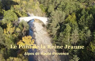
The Pont de la Reine Jeanne is a bridge located in the Alpes-de-Haute-Provence department, in the commune of Saint-Benoît in the Provence-Alpes-Côte d'Azur region. It crosses the Coulomp.
History The existence of a bridge at the site of the current bridge is attested in 1296.
In 1676, the community of the village of Saint-Benoît asked the provincial assembly to rebuild the bridge used to cross the river, made necessary by a rocky spur. The file was passed to the province's architect, Louis II Vallon. An estimate was drawn up in 1681. The construction was put up for auction in 1682. The auction was won by Garcin Pelet, a mason from Saint-Jaumes. A bridge was built and the works were accepted in 1685 and again in 1693. But it was quickly ruined because of a fault of the contractor, according to the mayor of Saint-Benoît.
In December 1712, the commissioners gathered at Lambesc decided "...to build the bridge of Saint-Benoît over the Coulomp river anew...". The procurators of the region visited the site on 12 September 1714. In 1727, the procurators noted that nothing had been done. They decided to follow up on "the report and estimate drawn up by Mr. Vallon, architect of the Province... especially since the work is urgent and requires speed".
At the sixth auction, on 15 February 1728, the work was entrusted to Joseph Blanc, a carpenter from Le Fugeret, for the sum of 6,180 livres. The price was raised by agreement to 9,180 livres on 22 April 1728. The works were to last 2 years. Construction continued until 1729. The works were accepted in 1734, then confirmed in 1743.
The masonry structure of the bridge has a double ring: the first of well-dressed stones, the second rougher, similar to that of the Fugeret bridge.
In the 18th century the bridge was called the bridge of Saint-Benoît. The name Pont de la Reine Jeanne is therefore recent.
The structure was listed as a historic monument on 19 January 1928.
Its name probably refers to Joan I of Naples. Main dimensions span: 29 m height of the arch keystone: 12.5 m length of the deck at parapet level: 42.15 m width of the roadway between parapets: 2.70 m thickness of the parapets: 0.40 m width of the right-bank abutment: 4.20 m
Map and restricted areas
Open in the main mapNearby aerodromes
Open aerodromes within 25 km of the spot, heliports included, with their distance and direction from the spot. Near an aerodrome, drone flying is prohibited or height-limited: check the UAS zones map.
| Aerodrome | Type | Distance | Elevation | Difference |
|---|---|---|---|---|
| Aérodrome de Sistéron-Vaumeilh | Aerodrome | 14 km NW | 540 m | spot 61 m higher |
| Aérodrome de Château-Arnoux - Saint-Auban | Aerodrome | 15 km S | 460 m | spot 141 m higher |
| La Motte du Caire Glider Field | Aerodrome | 15 km N | 650 m | spot 49 m lower |
Aviation weather (METAR and TAF)
No METAR station within 50 km.
Weather and Kp index
| Day | Weather | Temp. min. / max. | Wind | Rain | Max Kp |
|---|---|---|---|---|---|
| Sat 21 Nov | Fair | 5° / 13° | 10 km/h NW | – | 2 |
| Sun 22 Nov | Showers | 6° / 11° | 22 km/h NW | 22 mm | 2 |
| Mon 23 Nov | Partly cloudy | 3° / 8° | 22 km/h NW | – | 4 |
| Tue 24 Nov | Cloudy | 2° / 10° | 10 km/h N | 1.8 mm | 2 |
| Wed 25 Nov | Rain | 2° / 6° | 6 km/h N | 26 mm | – |
| Thu 26 Nov | Partly cloudy | -1° / 5° | 5 km/h NW | 0.3 mm | – |
| Fri 27 Nov | Fair | -2° / 6° | 5 km/h N | – | – |
Hour by hour: Saturday 21 November
| Time | Weather | Temp. | Wind | Rain | Clouds | Kp |
|---|---|---|---|---|---|---|
| 12:00 | Partly cloudy | 11° | 10 km/h NW | – | 44 % | 2 |
| 13:00 | Fair | 12° | 9 km/h NW | – | 20 % | 1 |
| 14:00 | Fair | 13° | 8 km/h NW | – | 23 % | 1 |
| 15:00 | Partly cloudy | 13° | 8 km/h W | – | 56 % | 1 |
| 16:00 | Partly cloudy | 12° | 3 km/h NW | – | 69 % | 2 |
| 17:00 | Partly cloudy | 9° | 4 km/h E | – | 89 % | 2 |
| 18:00 | Partly cloudy | 8° | 5 km/h E | – | 77 % | 2 |
| 19:00 | Partly cloudy | 7° | 6 km/h SE | – | 84 % | 2 |
| 20:00 | Partly cloudy | 6° | 5 km/h E | – | 88 % | 2 |
| 21:00 | Cloudy | 5° | 6 km/h E | – | 100 % | 2 |
| 22:00 | Cloudy | 6° | 6 km/h E | – | 99 % | 2 |
Hour by hour: Sunday 22 November
| Time | Weather | Temp. | Wind | Rain | Clouds | Kp |
|---|---|---|---|---|---|---|
| 06:00 | Heavy rain | 7° | 11 km/h SE | 2.0 mm | 100 % | 2 |
| 07:00 | Heavy rain | 8° | 13 km/h SE | 3.4 mm | 100 % | 2 |
| 08:00 | Heavy rain | 8° | 11 km/h SE | 5.2 mm | 100 % | 2 |
| 09:00 | Heavy rain | 9° | 6 km/h NW | 2.0 mm | 100 % | 2 |
| 10:00 | Rain | 9° | 8 km/h E | 0.5 mm | 98 % | 2 |
| 11:00 | Showers | 10° | 11 km/h E | 0.3 mm | 75 % | 2 |
| 12:00 | Rain | 11° | 16 km/h NW | 0.4 mm | 96 % | 2 |
| 13:00 | Showers | 9° | 18 km/h NW | 0.3 mm | 35 % | 2 |
| 14:00 | Showers | 10° | 19 km/h NW | 0.8 mm | 21 % | 2 |
| 15:00 | Showers | 9° | 19 km/h NW | 0.3 mm | 32 % | 2 |
| 16:00 | Clear sky | 8° | 21 km/h NW | – | 10 % | 2 |
| 17:00 | Clear sky | 8° | 21 km/h NW | – | 12 % | 2 |
| 18:00 | Fair | 7° | 22 km/h NW | – | 22 % | 2 |
| 19:00 | Fair | 7° | 19 km/h NW | – | 21 % | 2 |
| 20:00 | Clear sky | 6° | 18 km/h NW | – | 12 % | 2 |
| 21:00 | Fair | 6° | 17 km/h NW | – | 24 % | 2 |
| 22:00 | Partly cloudy | 6° | 16 km/h NW | – | 76 % | 2 |
Sunrise and sunset
| Day | Dawn | Sunrise | Golden hour | Sunset | Dusk | Day length |
|---|---|---|---|---|---|---|
| Sat 21 Nov | 07:07 | 07:39 | 07:39–08:24 · 16:19–17:04 | 17:04 | 17:36 | 9 h 25 |
| Sun 22 Nov | 07:09 | 07:40 | 07:40–08:25 · 16:19–17:04 | 17:04 | 17:35 | 9 h 23 |
| Mon 23 Nov | 07:10 | 07:42 | 07:42–08:27 · 16:18–17:03 | 17:03 | 17:35 | 9 h 21 |
| Tue 24 Nov | 07:11 | 07:43 | 07:43–08:28 · 16:17–17:02 | 17:02 | 17:34 | 9 h 19 |
| Wed 25 Nov | 07:12 | 07:44 | 07:44–08:29 · 16:16–17:02 | 17:02 | 17:34 | 9 h 17 |
| Thu 26 Nov | 07:13 | 07:45 | 07:45–08:31 · 16:15–17:01 | 17:01 | 17:33 | 9 h 15 |
| Fri 27 Nov | 07:14 | 07:46 | 07:46–08:32 · 16:15–17:00 | 17:00 | 17:33 | 9 h 14 |


Reviews
Log in to review this spot. Log in · Create a free account
No reviews yet. Share yours!