

Castel Lodrone
Aucun avis pour l'instant
Vous avez volé ici ? Partagez votre expérience avec les autres pilotes.
+ Donner le premier avisDescription
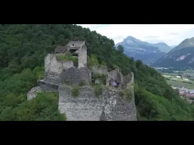
DJI Phantom 3 Crashes into the trees while filming Castello Lodrone Italy. It took 3 hours to get him out of the tree. The castle or fortress of Lodrone, also called Santa Barbara since 1600, was the oldest site of Lodron. It is remembered for the first time at the end of the twelfth century: in 1185 Calapino Lodrone, vassal of the counts of Appiano, was already established here; in 1189 the Prince Bishop of Trento invested Castle Lodrone thirteen men from Storo, who took over in Calapino Lodrone. It was phased out starting in the sixteenth century when the accounts they preferred the more comfortable residences manufactured along the Caffaro and Lodrone. Together with Castel Romano and Castel S. Giovanni has a type in which the military characteristics prevail over residential. The Santa Barbara was indeed a real stronghold, designed and built primarily as an instrument of war.
The external defense is compact, in many ways more than two meters thick, built with gigantic granite boulders machined accurately as to minimize the seams, high rise about six meters and no openings. The boundary follows a broken line and is closely connected to the tower in order to achieve the result of a castle-tower from the polygonal perimeter with spur that extends towards the mountain. One door gave access to the court and another introduced at the tower. The internal structures are almost entirely fallen and only the imagination of the visitor who observes the empty eye sockets of the round windows with the frames work in rough ashlar can sense a residential floor and in the vast square tower building. On the north side of it was a leaning tower which had both extreme defense. To the south and east, the complex was completed with a number of buildings, probably destined to services, and a semicircular torrioncino. In 1439 the castle was taken by Piccinino after a violent bombardment. It probably dates back to the subsequent reconstruction decoration with stone cannon balls inserted in warping walls. More info; http://goo.gl/rkGLHw
Carte et zones de restriction
Voir sur la grande carteMétéo aéronautique (METAR et TAF)
LIPO – Brescia Airport LIFR
METAR
METAR LIPO 171150Z AUTO VRB02KT 1300 R32/1700U -RA BR BKN004/// 08/07 Q1006 REDZ RERA
- Vent
- Variable, 4 km/h
- Visibilité
- 1,3 km
- Temps présent
- Pluie faible ; brume
- Nuages
- Fragmentés (5-7/8) à 400 ft (120 m)
- Température
- 8 °C, point de rosée 7 °C
- QNH
- 1006 hPa
- Catégorie de vol
- LIFR : plafond < 500 ft ou visibilité < 1,6 km
TAF
TAF LIPO 171100Z 1712/1812 VRB05KT 6000 BKN040 TEMPO 1712/1718 3000 RA BECMG 1718/1720 1500 BR BKN014 TEMPO 1722/1808 0800 BCFG BKN014
| Période (heure locale) | Évolution | Vent | Visibilité | Temps | Nuages |
|---|---|---|---|---|---|
| 17/11 13:00 → 17/11 19:00 | Conditions initiales | Variable, 9 km/h | 6 km | Fragmentés (5-7/8) à 4 000 ft (1220 m) | |
| 17/11 13:00 → 17/11 19:00 | Temporairement | 3,0 km | Pluie | ||
| 17/11 19:00 → 18/11 13:00 | Évolution progressive | Variable, 9 km/h | 1,5 km | Brume | Fragmentés (5-7/8) à 1 400 ft (430 m) |
| 17/11 23:00 → 18/11 09:00 | Temporairement | 800 m | Bancs de brouillard | Fragmentés (5-7/8) à 1 400 ft (430 m) |
Météo et indice Kp
Lever et coucher du soleil
| Jour | Aube | Lever | Heure dorée | Coucher | Crépuscule | Durée du jour |
|---|---|---|---|---|---|---|
| Mar. 17 nov. | 06:48 | 07:21 | 07:21–08:07 · 15:59–16:45 | 16:45 | 17:17 | 9 h 24 |
| Mer. 18 nov. | 06:49 | 07:22 | 07:22–08:08 · 15:58–16:44 | 16:44 | 17:17 | 9 h 22 |
| Jeu. 19 nov. | 06:51 | 07:23 | 07:23–08:10 · 15:57–16:43 | 16:43 | 17:16 | 9 h 19 |
| Ven. 20 nov. | 06:52 | 07:25 | 07:25–08:11 · 15:56–16:42 | 16:42 | 17:15 | 9 h 17 |
| Sam. 21 nov. | 06:53 | 07:26 | 07:26–08:13 · 15:55–16:41 | 16:41 | 17:14 | 9 h 15 |
| Dim. 22 nov. | 06:54 | 07:27 | 07:27–08:14 · 15:54–16:41 | 16:41 | 17:13 | 9 h 13 |
| Lun. 23 nov. | 06:56 | 07:29 | 07:29–08:16 · 15:53–16:40 | 16:40 | 17:13 | 9 h 11 |
Avis
Connectez-vous pour donner votre avis sur ce spot. Se connecter · Créer un compte gratuit
Aucun avis pour l'instant. Partagez le vôtre !