

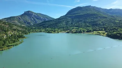
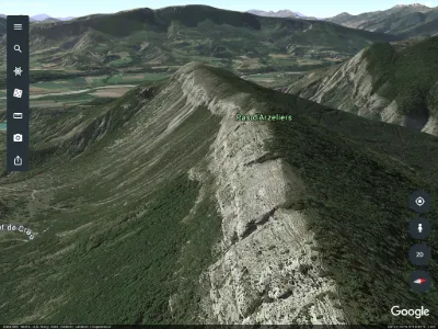
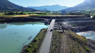
St Genis, the Riou lake

No reviews yet
Have you flown here? Share your experience with other pilots.
+ Write the first reviewDescription
This 16 ha lake will delight nature lovers. Tree-lined beaches with grass and gravel. Swimming on 2 beaches, one of which is supervised in summer. Located between Eyguians and Saint Genis, it offers picnic tables, barbecues and play areas.
Pedal boat, stand-up paddle and canoe rentals at the water sports center. A snack bar offers drinks, ice cream and light meals. Toilets on site. Please remember that, for everyone's hygiene and safety, activities at the Riou leisure area are governed by several municipal orders: - Swimming is prohibited when the red flag is raised, - Only fires in barbecues are allowed, - Dogs must be kept on a leash and are not allowed in swimming areas, on the beaches or behind the beaches, - Wild camping is prohibited, - Motorhomes may park for a maximum of 48 hours.
Map and restricted areas
Open in the main mapNearby aerodromes
Open aerodromes within 25 km of the spot, heliports included, with their distance and direction from the spot. Near an aerodrome, drone flying is prohibited or height-limited: check the UAS zones map.
| Aerodrome | Type | Distance | Elevation | Difference |
|---|---|---|---|---|
| Serres - La Bâtie-Montsaléon Airfield | Aerodrome | 10 km N | 715 m | spot 43 m lower |
| Altisurface du Grand Terrus | Aerodrome | 12 km NW | 875 m | spot 203 m lower |
| Aérodrome de Sistéron-Vaumeilh | Aerodrome | 15 km SE | 540 m | spot 132 m higher |
| Aérodrome d'Aspres-sur-Buëch | Aerodrome | 17 km N | 831 m | spot 159 m lower |
| La Motte du Caire Glider Field | Aerodrome | 21 km E | 650 m | spot 22 m higher |
Aviation weather (METAR and TAF)
No METAR station within 50 km.
Weather and Kp index
| Day | Weather | Temp. min. / max. | Wind | Rain | Max Kp |
|---|---|---|---|---|---|
| Sat 21 Nov | Fair | 5° / 14° | 8 km/h NE | – | 2 |
| Sun 22 Nov | Showers | 6° / 10° | 24 km/h NW | 23 mm | 2 |
| Mon 23 Nov | Cloudy | 4° / 8° | 23 km/h NW | – | 4 |
| Tue 24 Nov | Cloudy | 2° / 10° | 12 km/h NW | 2.0 mm | 2 |
| Wed 25 Nov | Rain | 2° / 5° | 6 km/h E | 25 mm | – |
| Thu 26 Nov | Partly cloudy | 0° / 6° | 5 km/h NW | 2.7 mm | – |
| Fri 27 Nov | Fair | -2° / 6° | 3 km/h NW | – | – |
Hour by hour: Saturday 21 November
| Time | Weather | Temp. | Wind | Rain | Clouds | Kp |
|---|---|---|---|---|---|---|
| 12:00 | Partly cloudy | 12° | 5 km/h SW | – | 47 % | 2 |
| 13:00 | Fair | 13° | 6 km/h SW | – | 20 % | 1 |
| 14:00 | Fair | 14° | 6 km/h W | – | 24 % | 1 |
| 15:00 | Partly cloudy | 14° | 7 km/h W | – | 60 % | 1 |
| 16:00 | Partly cloudy | 12° | 7 km/h SW | – | 57 % | 2 |
| 17:00 | Partly cloudy | 9° | 5 km/h SW | – | 93 % | 2 |
| 18:00 | Partly cloudy | 7° | 4 km/h NW | – | 78 % | 2 |
| 19:00 | Partly cloudy | 6° | 3 km/h NW | – | 75 % | 2 |
| 20:00 | Partly cloudy | 6° | 3 km/h NW | – | 86 % | 2 |
| 21:00 | Cloudy | 5° | 4 km/h N | – | 100 % | 2 |
| 22:00 | Cloudy | 6° | 6 km/h NE | – | 100 % | 2 |
Hour by hour: Sunday 22 November
| Time | Weather | Temp. | Wind | Rain | Clouds | Kp |
|---|---|---|---|---|---|---|
| 06:00 | Heavy rain | 6° | 9 km/h NE | 2.7 mm | 100 % | 2 |
| 07:00 | Heavy rain | 6° | 9 km/h NE | 4.6 mm | 100 % | 2 |
| 08:00 | Heavy rain | 6° | 9 km/h NE | 2.7 mm | 100 % | 2 |
| 09:00 | Heavy rain | 7° | 6 km/h E | 1.4 mm | 100 % | 2 |
| 10:00 | Rain | 8° | 13 km/h N | 0.6 mm | 100 % | 2 |
| 11:00 | Rain | 9° | 19 km/h W | 0.7 mm | 93 % | 2 |
| 12:00 | Showers | 10° | 22 km/h NW | 0.4 mm | 80 % | 2 |
| 13:00 | Showers | 10° | 20 km/h NW | 0.6 mm | 66 % | 2 |
| 14:00 | Showers | 10° | 21 km/h NW | 0.7 mm | 57 % | 2 |
| 15:00 | Partly cloudy | 8° | 19 km/h NW | – | 56 % | 2 |
| 16:00 | Fair | 8° | 20 km/h NW | – | 16 % | 2 |
| 17:00 | Fair | 8° | 20 km/h NW | – | 22 % | 2 |
| 18:00 | Fair | 7° | 17 km/h NW | – | 32 % | 2 |
| 19:00 | Clear sky | 7° | 18 km/h W | – | 12 % | 2 |
| 20:00 | Fair | 6° | 19 km/h W | – | 33 % | 2 |
| 21:00 | Partly cloudy | 6° | 19 km/h W | – | 67 % | 2 |
| 22:00 | Partly cloudy | 6° | 23 km/h NW | – | 74 % | 2 |
Sunrise and sunset
| Day | Dawn | Sunrise | Golden hour | Sunset | Dusk | Day length |
|---|---|---|---|---|---|---|
| Sat 21 Nov | 07:09 | 07:41 | 07:41–08:26 · 16:20–17:05 | 17:05 | 17:37 | 9 h 24 |
| Sun 22 Nov | 07:10 | 07:42 | 07:42–08:27 · 16:19–17:04 | 17:04 | 17:36 | 9 h 22 |
| Mon 23 Nov | 07:11 | 07:43 | 07:43–08:29 · 16:18–17:03 | 17:03 | 17:35 | 9 h 20 |
| Tue 24 Nov | 07:12 | 07:44 | 07:44–08:30 · 16:17–17:03 | 17:03 | 17:35 | 9 h 18 |
| Wed 25 Nov | 07:14 | 07:46 | 07:46–08:31 · 16:16–17:02 | 17:02 | 17:34 | 9 h 16 |
| Thu 26 Nov | 07:15 | 07:47 | 07:47–08:33 · 16:16–17:02 | 17:02 | 17:34 | 9 h 14 |
| Fri 27 Nov | 07:16 | 07:48 | 07:48–08:34 · 16:15–17:01 | 17:01 | 17:33 | 9 h 12 |


Reviews
Log in to review this spot. Log in · Create a free account
No reviews yet. Share yours!